Triangle Trade and Physics
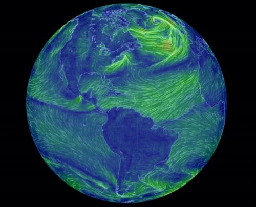
You have heard of the Atlantic triangle trade in school. It is always discussed in terms of its economic logic (e.g. English rum to African slaves to New World sugar). But the trade has a physical logic as well in the sailing ship era. Current wind patterns:
Real time version here. Via Flowing data.
Seriously, click on the real time link. Even if you are jaded, probably the coolest thing you will see today. One interesting thing to look at -- there is a low point in the spine of the mountains of Mexico west of Yucatan. Look at the wind pour through it like air out of a balloon.

British cloth to Africa, slaves to the Caribbean, sugar to New England, rum to England (or sugar to England direct) is the sequence we learn in Britain. But yes, you're absolutely correct, wind driven. And to go to India around the Cape of Good Hope youfirst charge off across the Atlantic to somewhere off Brazil. Which is how the Portuguese found the place, going a bit too far.
My teacher knew that the routes followed the trade winds. Also, the equatorial current, gulfstream, North Atlantic drift current, and Canary currents are in the right direction as well.
This is the sort of thing we were taught early in secondary school, I think, under the name "physical geography". Our last topic is phys geog, however, was a real snorer - oceanic oozes.
This is pretty cool.
I'm reading a book right now about some of my high school friends who circumnavigated the globe in a 41ft. sailboat after college. It was less than 20 years ago but they had no email or cell phones and struggled in the middle of the Pacific trying to find Easter Island with a cranky, first generation GPS. They would have killed for something like this while floundering around in the doldrums. On the other hand they state repeatedly that they’re glad they were comparatively tech-free at the time and how very different the experience would be (better and worse) today.
Anyway,
here are two cool historical data animations:
Atomic Bomb explosions:
http://www.upworthy.com/an-artist-counted-every-atomic-explosion-on-earth-and-shows-them-all-in-a-matter-of-seconds-3?c=ufb1
And the first 100 years of globalization (1750-1850) illustrated via a near-exhaustive recreation of every trans-ocean voyage in that period, transcribed from log book data:
http://www.youtube.com/watch?v=tnqxrcfUMsw
Thanks! Very cool.
Yes, very, very cool! It's not obvious, but you can get winds aloft, as well, all the way up to the upper stratosphere! Thanks for the link!
Vikings to Iceland/Greenland/Canada and back. Going by today's map, looks like the return trip would have been an order of magnitude faster.
That's pretty bloody neat, all right. Thanks!