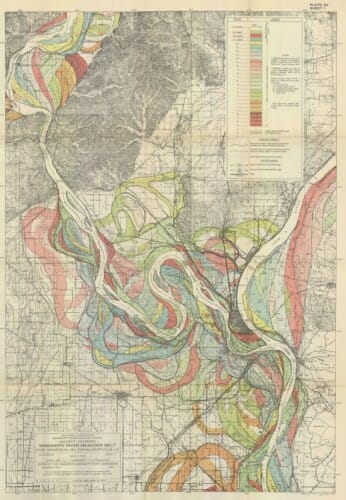
Changing Flow of the Mississippi River
I thought this was an incredibly cool image, showing the changing path of the Mississippi River (in this case where it meets the Ohio). (via Flowing Data)
When I was a kid, I was fascinated by water flow and erosion. I remember spending a whole day on a woodside hill watching the evolution of an ad hoc stream of water, playing around with damming it in some places, creating new channels, etc. When I went to the beach, I never built castles but attempted to build walls and channels to shape the way the tide flowed. Since I am free associating, I also remember visiting a huge model of the Mississippi, I think near Vicksburg, that I thought at the time was the coolest thing on Earth. Not even sure today if it still exists.

The Army Corps of Engineers Research facility in Vicksburg had (still has?) a full model of the Mississippi River used for research, planning, model development and evaluation, and as a cool tool for public relations.
I remember a large outdoor concrete map of the Mississippi in Memphis many years ago.
There is a functioning model of the river on Mud Island, in Memphis. Very worth seeing if you're in town.
You "NEED" to read David Haddock's paper (Professor of Economics and Law at Northwestern University) on the Army Corp's attempts to divert the flow, and the possibility of a real disaster down there if the Atchafalaya decides to get a bit hornery.
"When I was a kid, I was fascinated by water flow and erosion."
So . . you admit to being a closet Fluvial Geomorphologist?
Do you know where your meandering thalweg is right now?
Did we grow up in the same house in suburban Houston? Or are you talking about our summers in Wyoming? Even so, I don't remember as much fascination with water as I do our attraction to the caves we found and the match books we stole.
We're just trying to finish our backyard landscaping and have a dirt hill that my 7 and 9 year old daughters have taken to using exactly like you describe your woodside hill....they take the hose and have carved canyons with water, dug channels, built dams, and witnessed "disasters", all in minature.
I had just stood at the kitchen window watching them play and was thinking back to my childhood before I happened to check in on your blog. It brought a smile to my face...I realized their beach play this summer involved more water than castles too...my 9 year old is also interested in maping.
Here's to play, fascination, and curiosity! May they keep us young.
Note the changes in channel width as well as path. This map demonstrates a river can be anywhere and nearly any shape within the flood plain (which for the Mississippi River can be 50+ miles wide). Model that!
And in the Great Mississippi River Flood of 1927 the river used ALL of its flood plain reaching 60 miles wide near Memphis TN.
I used to do the same thing as a kid. When my dad's tractor drove through puddles, its tires would leave a number of pits and ridges that I'd connect and block, attempting to create little floods.
Changing path of the greatest river, Old and the New, not just cool it is super cool.